Wednesday, October 17, 2007

Yellowstone and Grand Tetons

Home at last...

We are now happily home after more than seven weeks away. We drove more than 10,000 miles and spent... well, I really don't want to add it all up! Tabette is all covered up and put away for the season, waiting for our next outing next spring perhaps. (That's Tabette on the left.)


Tuesday, October 9, 2007
We left the cabin and drove through Yellowstone, this time through Canyon Village and Yellowstone Lake. Here's a colorful view of the Yellowstone River near Mammoth Hot Springs and the sleepy bison at the lower terrace.


We stopped to view the lower falls near Canyon Village and had lunch at Yellowstone Lake. It was finally a lovely, warm day so we took full advantage. We found one of the few picnic tables still accessible on the lake. Lots of the access roads were covered with snow since it had snowed quite a bit over the weekend. As a matter of fact, two of the roads through the park were still closed.


When going south out of Yellowstone National Park, you drive right into Grand Teton National Park in the Bridger Teton National Forest. The sun was just perfect to show the colors but unfortunately this picture does not really show the gorgeous yellows. But here's one of the first views you get of the Grand Tetons from the north from Yellowstone. We stopped overnight at Jackson, Wyoming and then drove home the next day. Here's one shot taken just south of Jackson.


Monday, October 8, 2007
We took a ride to Bozeman to check it out and have lunch. Then we took a ride up north and east of Bozeman. As you can see, the area is very beautiful.


Sunday, October 7, 2007
On Sunday we finally got to go into Yellowstone to see Old Faithful. Of course it started snowing so we couldn't get any good pictures of the geyser. But we had a great tour of the Yellowstone Inn and we saw a few lazy bison on the roadside.


Here are a couple of photos of the upper and lower terraces near Mammoth Hot Springs. Not very appealing.


Roxie meets skunk

While at the cabin, the dogs were quite funny. Both being terriers, they each thought they were the only dog in the house. They'd walk past each other and pretend they didn't see each other. One night, I opened the front door to let Roxie outside. Thankfully, I had her on the leash because the skunk that was getting into the garbage, wasn't about to give it up. (The person who put the garbage bag temporarily on the front porch shall remain nameless.) Roxie immediately jumped on the skunk while I tugged on the leash as hard as I could. After what seemed like an hour, I was able to drag Roxie off the skunk and pull her back into the house. I slammed the door just before the skunk left its mark on the front of the house. For the next few days we had to live with the skunk smell in the front rooms and Roxie had to have another bath when we got home.

Thursday, October 4, 2007
We followed I94 through North Dakota and stopped at this rest area near Medora. It's a view of the Painted Canyon in Theodore Roosevelt National Park. It reminds me of the Painted Desert in Arizona. The national park is in Little Missouri National Grasslands.


Then it was into Montana, the final leg of our journey, for a few days anyway. We were joining my sister Bonnie, her husband Alan, and their dog Jasmine. They had rented a cabin just south of Livingston, right on the Yellowstone River.

This picture shows the view from the balcony at the cabin. The next two days were rainy, snowy, and windy so I hung out in the cabin enjoying the view.

Wednesday, October 3, 2007

Touring Northern Ontario and Northern Michigan

Wednesday, October 3, 2007

We're in Bismark, North Dakota. What a trip it's been these past four days driving from Maine! I thought the roads in Nova Scotia and PEI were bad but Quebec and Ontario win the prize. They also win for worst signage.

Tomorrow we'll meet my sister Bonnie and brother-in-law Alan in Yellowstone and we'll continue the party for a few more days. It's an unexpected but delightful way to end my trip.

Sunday, September 30, 2007

We left Cindy and Jim’s on Sunday morning and drove to just south of Montreal. We took route 91 from Vermont to Canada and then went west toward Montreal, then south to the KOA. Taking that route was a big mistake it turns out, not only because the roads made you seasick, but also because the KOA was right on route 15, which I could have taken from New York (instead of going through Quebec). Long story short, on Monday morning I must have wasted about 2 hours following the directions they gave me to get to Ottawa without going into Montreal (how many constructions zones can one province have anyway?). I ended up going through the border crossing at Elvira NY and then back into Canada at Cornwall.

Monday was a very long day driving (13 hours) and we only got to Sudbury, Ontario. The last few hours were horrible. The roads were all torn up and under construction. It was raining and pitch black. Impossible to see. We drove around Sudbury for a couple of hours trying to follow directions to the campground but I couldn’t see the signs. Finally found it at around 9:30. I had a huge surprise waiting inside Tabette. The curtains were on the floor, the cabinet with the clothes had opened and the clothes were on the bed. The knob to shut the ceiling fan vent was on the floor and I couldn’t reattach it without taking the entire assembly out. The vent cover was stuck open too. All in all, it was a very bad day. Probably the worst day of this entire trip.

Tuesday was a better day. We drove across Northern Ontario and into Michigan at Sault Ste. Marie. Then we drove along the southern shores of Lake Superior on route 28. Most of the time the drive was very scenic and the road was pretty good. Here are a couple of pictures taken from the highway around Espanola in Northern Ontario. From Sudbury to the western border was very nice; lots of lakes and lots of folks with canoes on top of their cars.


Northern Michigan is also very beautiful. They have lots of places to stop and view Lake Superior.


We stopped at a lovely campground just outside Michigamme. Roxie had a good walk and we relaxed before it got dark. The time change is tomorrow at the Wisconsin border. It poured all night and even though the vent cover was stuck partially open, it didn't get wet inside Tabette.

It’s interesting the different questions asked by the border guards at the border crossings. My first crossing into Canada was at Port Huron; the guard asked if I had any guns or other weapons like mace or pepper spray. He wanted to know if I was taking any alcohol into Canada too. When I crossed from Ontario into NY at Cornwall (the first time), the woman basically read from a script, wanting to know if I had made any purchases in Canada and what was my place of residence. When I crossed into Canada at Campobello Island, the guard asked where I was going in Canada and why. He also asked about weapons. I was asked to pull over and a female officer looked in the trailer, checking for people being smuggled in I presume. We had a delightful conversation about the size of the trailer and she said to have a great vacation in Canada. Coming back to the US from New Brunswick, the US border guard asked where I had been and if I had made any purchases. Then he said “Welcome home.”

When I crossed into Ontario from Vermont on my way home this time, the guard asked if I had any guns, rifles, or automatic weapons. I said “No.” Then she said, “Do you own any guns, rifles, or automatic weapons?” After hearing my response, I noticed a trace of a smile and she sent me on my way. By accident, the next day I crossed into the US again at Cornwall. The Canadian guard was very helpful, telling me how to get going back toward Ottawa without backtracking, but it meant I would have to cross back into the US. The young lady at that crossing (which was only several feet away from the Canadian crossing) was very friendly, but she opened the back of my car and took the keys to Tabette. She opened the door and peaked in but didn’t make any comment. I suppose she was looking for illegal aliens, weapons, or undeclared purchases, but she didn’t explain her reasons.

Today was my last crossing into the US, at Sault Ste. Marie, over the big bridge. The crossing guard asked where I was from, how long I had been in Canada (that was hard to explain), and what I had purchased in Canada.

It seemed that the Canadian guards are concerned about weapons and alcohol, while the American guards are concerned about what you purchased. I don’t remember that any American guard asked about weapons. It was kind of surprising.

Sunday, September 30, 2007

Leaving New England

Hi All,
We are now just south of Montreal. I'll try to catch you up on what's been happening with us. We changed our plans to go south on the way home because my sister Bonnie invited us to join them in Yellowstone for a few days. So now I'm heading directly west to Montana via Quebec and Ontario. We are sorry to be leaving New England and the fall colors. It's not quite peak season for the colors, so I haven't taken any good fall color pictures yet. I hope to get some in Ontario tomorrow and maybe the next day.

Sunday, September 30, 2007
For the past few days we've been playing in and around coastal Maine: Hancock, Bangor, Ellsworth, and Schoodic Point (part of Acadia National Park). My cousin Cindy had her shop open for the weekend so we were busy getting furniture painted and ready for the sale.

Yesterday, my cousin Pete took me for a ride on his Honda motorcycle. It was a warm and sunny day. We rode out to Schoodic to watch the waves. On the way, we stopped in Winter Harbor to look at a fish packing plant and the wharf where they unload and package lobster. While we were there, hundreds of sea gulls swarmed above us and unfortunately left a couple of gifts on my cousin's motorcycle. After Pete cleaned off his motorcycle, we proceeded to the real mission -- to see the wonderful rocks and water at Schoodic Point.


On Thursday I drove up to Smyrna to visit with my cousins Dennis and Kathy. My cousin Kenny from Ohio was even there visiting, and my mother's cousin Betty came over too. We had a very pleasant time telling stories and looking at old family pictures. On the way home I saw a lovely young Moose along the highway!
This picture shows the view toward Mt. Katahdin in Baxter State Park.
Too bad the weather didn't cooperate that day. But you can see some of the fall colors, which were probably about at their peak that week.
The drive up from Bangor is a very easy drive (about 2 hours) with very little traffic. I remember driving up as a kid (before the highway was in) and it was a 12-hour trek from home in Connecticut back in those days.


Monday, September 24, 2007
We left the Markland Resort and drove along the western shore of Cape Breton. It was very windy, which made the waves pretty outstanding.


Cape Breton is a delightful place. The people are very friendly and natural. The scenery is outstanding and the roads were uncrowded (although bumpy). They had road signs like this "/\/\/\" which I discovered meant "bumpy road ahead". These signs were on most roads in Canada, and yes I checked my tires often.


The eastern side of Cape Breton is just as spectacular as the western side. We took a ride down to Smokey Mountain.

Speaking of signs, I love this sign indicating that you shouldn't ever turn your back on the ocean.


Since the weather wasn't great on the day we left Cape Breton, we drove straight through to Five Islands on the Glooscap Trail, hoping to see the tidal bore. Turns out you’d have to stand around for about 6 hours to see anything and low tide was at around 5:30, so high tide would be around midnight. But here are some pictures of the area. We camped again right on the edge overlooking the Bay of Fundy.


We very much enjoyed our time at the resort in Cape Breton. Here are some photos taken from the deck off my room. As you can see, you can't see another house, road, or person. It would be a great retirement job to work here during the summers. But the women who worked there didn't seem to cozy up to the idea of giving up their jobs. Roxie had the option of being on the lawn or the porch or going inside to relax in her kennel.


I meant to take photos of the showers I've encountered on this trip, but I never did it. But I can tell you they run the gamut from open-air shower (no heat) complete with spider webs, to state-of-art spa-quality bathrooms. Excuse me, in Canada, it's a 'wash room.' Now I understand why most campgrounds close in early September - they have no heat in the restrooms! I found the nicest spa-like bathrooms at some KOA's and at the upscale campground in Vermont (Smuggler's Notch). That restroom even had an indoor water fountain (like someone would want to meditate in a campground restroom).

Friday, September 21, 2007

Touring Nova Scotia and Cape Breton Highlands National Park

Friday September 21, 2007
It's been about a week since I've had real internet access. I have to chuckle at these places that claim to have internet access. The last campground had a room with a phone and I was told I'd have to have my own modem and toll-free IPS number. Chuckle. I did finally find internet access at the Gaelic College ($2.00 for as long as you want).

This morning I came up the Cabot Trail along the northwest shore of Cape Breton. Spectacular scenery. I'll post some photos from the road. And a couple of pictures from the resort I'm staying at (Markland Resort). It's very beautiful here; I could definitely stay longer than three nights. Tomorrow I plan to spend some time at a place called Meat Cove, where they say you can see the whales playing. It's just up the road and it's really at the northern end of the island.


This last photo is the beach at the resort. It's a short walk though a field of wild flowers and a small woods. Roxie had a ball chasing the waves.


Wednesday, September 19, 2007

Today was another warm sunny day, but windy at the ocean. We went through Sydney, the largest city in Cape Breton, and Glace Bay on our way to the Fortress of Louisbourg, a national historic site of Canada. The fortress has been partially restored over the past 20 years. It was originally a fortified seaport founded by the French in 1713 to protect French interests in Quebec. It was captured by the British in 1745, and then given back to France by treaty in 1748. The British changed their minds again and recaptured the fortress in 1758 and again sent the French inhabitants back to France. I’m sure the French were very tired of this after the second time. To make things worse, the British blew up the fortress in 1760, and then withdrew their troops in 1768. At any rate, the reconstructed buildings were very interesting to tour. They had thousands of historically accurate artifacts, not to mention the pigs, turkeys, and chickens in the King’s Bastion. Twice a day they have a military demonstration that includes shooting a cannon. This picture shows several of the hundreds of cannons that protected the fortress and outlying lands from the British.


The next is a view of the fortress and a typical fisherman’s house.


This is the lighthouse in Louisbourg.


Monday & Tuesday, September 17 & 18, 2007

Today we drove from Peggy’s Cove to Antigonish, stopping at Clam Beach Provincial Park for a picnic. The first two photos show the lighthouse at Peggy's Cove and the view from the lighthouse. It's said to be the most photographed of all lighthouses in Canada. You can see why. Unfortunately though, lots of people like to see it. Fortunately for me I got there early, before the crowds. On my way out I saw at least a dozen tour buses loaded with folks on their way in to see the lighthouse. I couldn't have given T@B tours to so many people.


Next day (Monday) we drove to North Sydney. Tomorrow we’ll tour the Fortress of Louisbourg historic site.


Sunday, September 16, 2007

Today at least the sun was out when I got up. We broke camp quickly and headed south and then east along highway 103 (the Lighthouse Trail). Stopped at a lighthouse that was being repaired (Baccaro Light ) and a lighthouse in a little park next to a working peer (Medway Lighthouse Park). We drove through Lunenburg and Riverport, with a stop at The Ovens Natural Area. Checked out a campsite there and it was beautiful. On a rock overlooking the ocean. But it was too remote and there were no hookups, and just an outhouse. Then we drove all the way up to Peggy’s Cove. We’re staying at a campground just outside Peggy’s Cove so we can stop there in the morning and then head up the coast. There is a place on the other side of Halifax that sounds like it would be nice to see. Then we’ll head for Cape Breton Island. I think I’ve been anxious to settle in somewhere and stop all this driving. On Friday, we go to the Markland resort at the top of Cape Breton, so we want to be within a couple of hours of there the night before (Thursday).

Saturday, September 15, 2007

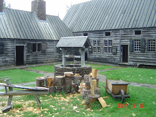
Sure enough, it was raining when we woke up this morning. We left the Plantation campground as soon as we could and started driving down route 101 along the northern coast of southwest Nova Scotia. We stopped at Annapolis Royal and toured Port Royal, which is a re-creation of the oldest permanent European settlement north of St. Augustine, Florida. They slept on horsehair mattresses (if you could call them mattresses). It was very dark, rustic, and lacked any feminine influence. It appeared to house only soldiers and gentlemen. There was lots of wood to be chopped and the cannons protected them from marauding folks.
Before I could make my way to the Port Royal tour, I had to give T@B tours to an entire busload of tourists from the US. It was really pretty funny, but they had a lot of questions. Then I went downtown to Annapolis Royal to tour the Fort Anne site. I decided against doing the tour and I just walked around the grounds. I was accosted by a couple who wanted to see inside the cute little trailer. Then it started really pouring so I headed south. Drove until I found a campsite at Darling Lake. Saw three lighthouses on the way.